Important news about the threat to the Dept of Archaeology at the University of Sheffield... Read more...

Since 2009, ArchAtlas has hosted a number of new stand-alone visual essays which follow on the model of Sherratt’s original papers and the ArchAtlas workshop papers, by a variety of authors. They are listed here below.


Steps Toward the Study of Seasonality and Trade
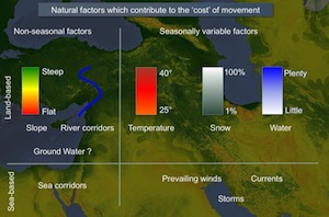
For the most part, the study of large-scale trade and exchange in the ancient world remains distanced from the physical hardships of real human travel. Ancient trade or, more neutrally, ancient ‘interaction’ is often discussed as if it took place between actors who inhabited a flat and unchanging spatial surface. In fact, topography, climate and seasonality are essential to understanding the changing forms and intensity of human travel that enabled ‘interdependence’ between communities of the Near East. This paper demonstrates some of the steps needed to reintegrate seasonality with the study of ancient trade.

Geospatial Analysis of Aguadas

Water has been a principal concern for Maya people inhabiting much of the Yucatan Peninsula for millennia. As a result, studies of water management in the Maya region contribute significantly to our understanding of ancient Maya civilization and its environmental adaptations. Aguadas, water storage ponds of varying size, have been an understudied aspect of Maya water management systems. Recognizing the origins and functions of aguadas provides a more complete picture of ancient Maya water management strategies. In this study, we analyze aguadas geovisually and geospatially in the southern Maya lowlands.

Introduction to Remote Sensing data for Global Archaeology

This document briefly introduces some of the key sources of spatial data from remote sensing sources, and a few other data types which have been particularly useful for archaeological research, and in particular, in the construction of .