 Occasional Papers (2009-)
 Site Visualisations
1) This sequence of maps illustrates a paper presented at the conference "New Perspectives on the Origins and Spread of Farming in Southwest Asia and Europe" in December 2003, sponsored by the AHRB. A full written version of the paper will be found in the conference publication (see end). The maps and satellite images are provided here with an abbreviated commentary.
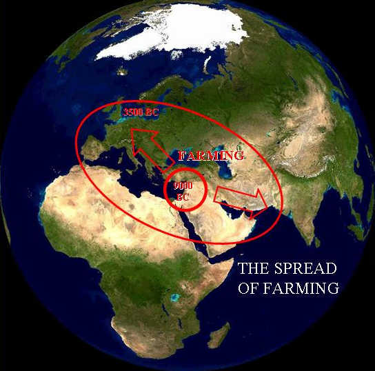
2) The complex of wheat, barley and legume cultivation (together with the keeping of domestic livestock), which originated in the Fertile Crescent of the Near East, emerged in the early Holocene and by 3500 BC extended from Ireland to Baluchistan. (Blue Marble)
3) What happened within this "nuclear area", and what geographical patterns lay behind the development of farming? (Blue Marble)
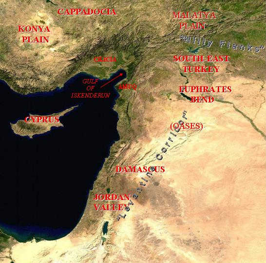
4) The Fertile Crescent is a region of stark environmental contrasts, with mountain ranges (created at the convergent plate boundary between Africa and Eurasia) catching the moisture brought by westerly winds travelling along the Mediterranean, bringing water to otherwise desert areas. Although important changes in rainfall have taken place since the early Holocene, this structure underlies the pattern of potential vegetation. Two important early routes of contact ran between the desert and the hills, around the northern margin of the Crescent: the eastern wing, which Robert Braidwood called the "hilly flanks area", and the western wing (following oases in the Syrian desert, and then the Jordan Rift) which Ofer Bar-Yosef has called the "Levantine corridor". (Blue Marble)
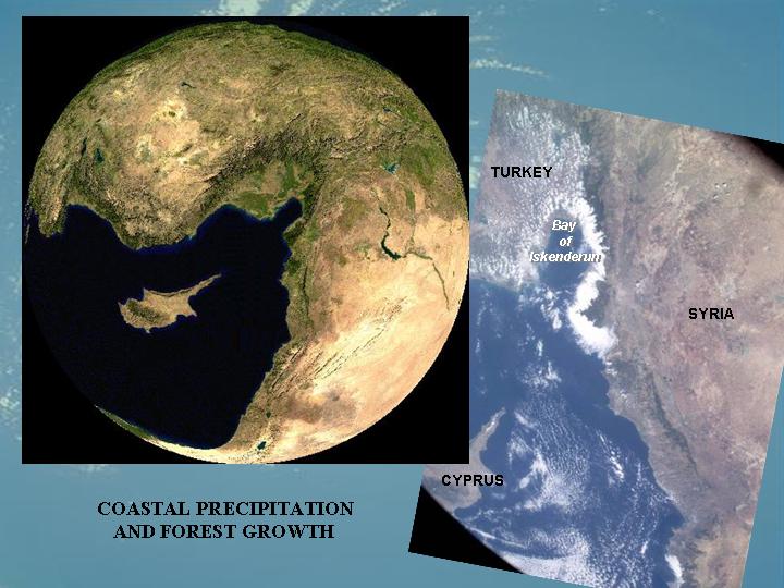
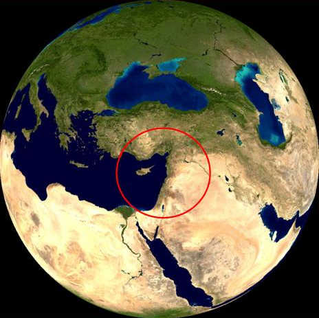
5) The north-east corner of the Mediterranean, around the Gulf of Iskenderun in southern Turkey and north-west Syria, catches frequent cyclones and would have supported relatively dense montane and coastal forests, as can be seen in this natural-colour MODIS image (Blue Marble) and hand-held astronaut photograph (NASA). These forested zones only show evidence of farming communities in the later Neolithic, after 7000 BC.

Some of the most important sites with evidence for early farming lie along the Jordan valley, a continuation of the rift system which separates Africa from Arabia, beginning in east Africa and extending up the Red Sea and the Gulf of Aqaba, and running parallel to the Levantine coast as far north as Kahramanmaraş in Turkey. In the southern Levant, the Jordan rift forms an internal drainage basin around the Dead Sea, where the high evaporation rates result in the accumulation of highly saline waters, some 400 m below sea-level.
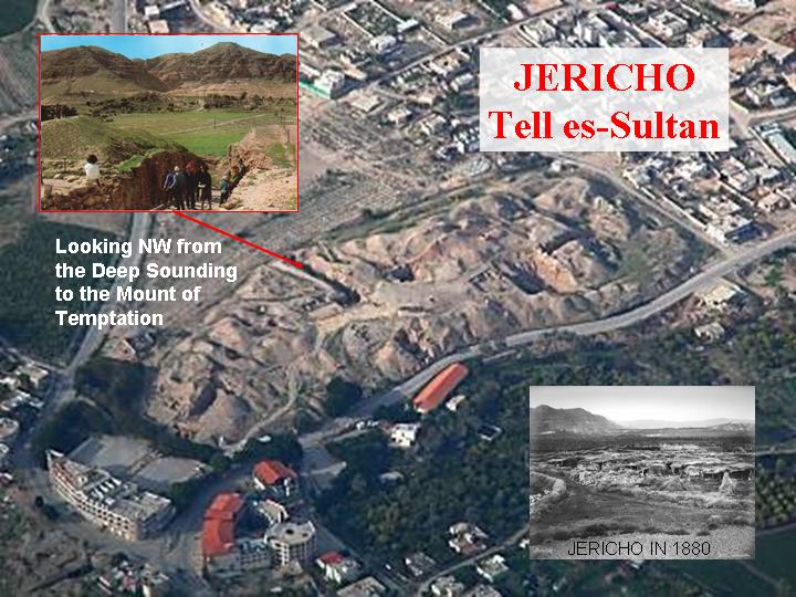
6) The site of ancient Jericho (Tell es-Sultan) occupies a well-watered location in an oasis at the base of the Judean hills on the edge of the rift valley, some 10 km north of the Dead Sea. The site has been continuously occupied by sedentary populations for more than 10,000 years, throughout the Holocene. The Neolithic levels were exposed at the bottom of a deep sounding dug by Dame Kathleen Kenyon in the early 1950s. The surroundings of the site have been greatly disturbed by recent building. (Click on the image to see the tell from a high resolution satellite image)
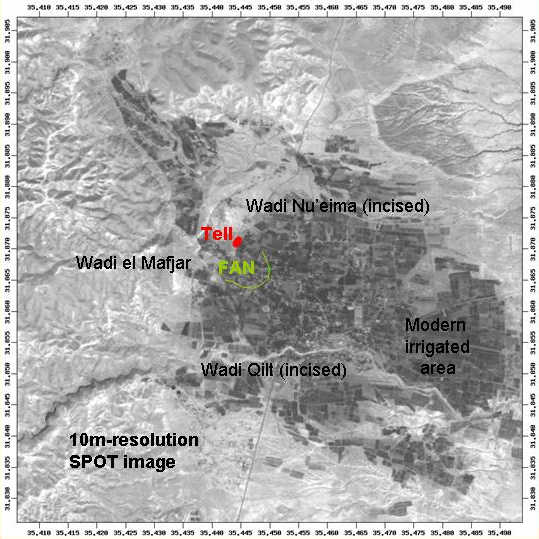
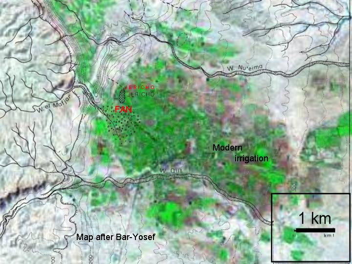
7) A SPOT image shows the relation of the tell to the cultivated oasis, now greatly extended by modern irrigation. The site is located at the outlet of the Wadi el Mafjar (which contains numerous springs), which has accumulated a small fan where it enters the plain. To the north and south are other wadis, now incised. A major spring, the Ain es-Sultan, emerges just below the tell. Flows of water from limestone reservoirs reflect rainfall on the Judean hills, and have a strongly seasonal pattern.
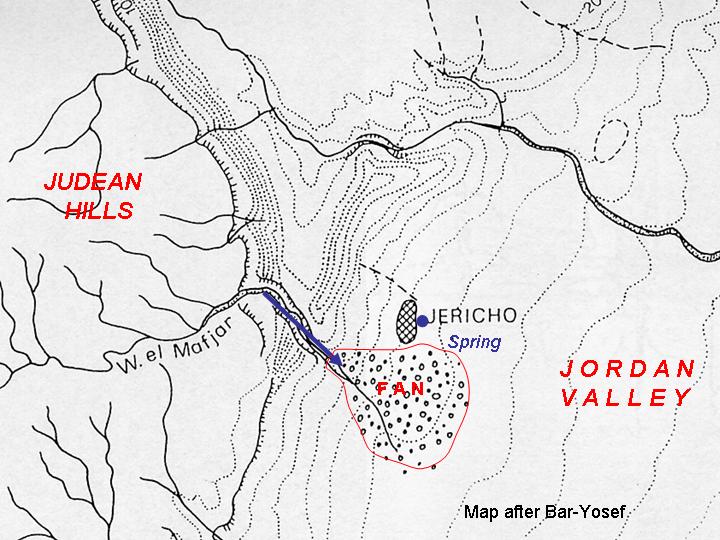
8) This plan of the surroundings of the site was compiled by Ofer Bar-Yosef and accompanied his article "The walls of Jericho: an alternative interpretation", Current Anthropology 27, 157-62 (1986).
9) The preceding map, superimposed on a Landsat 5 (30m) image.
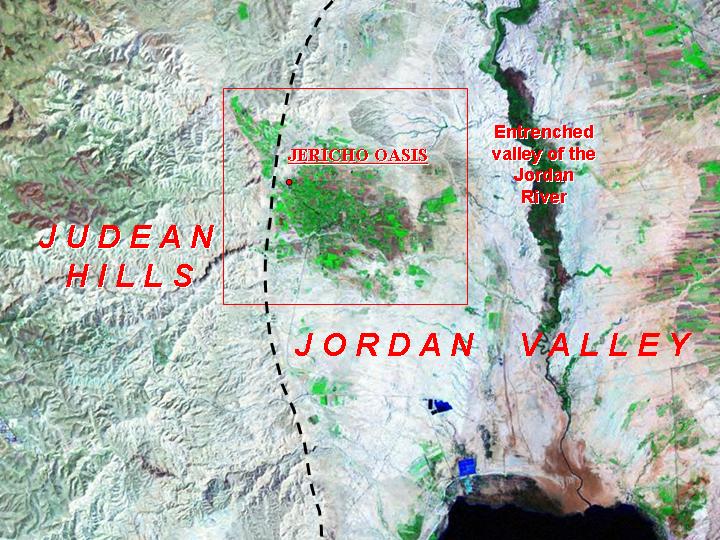
10) The setting of the Jericho oasis (Landsat 5 image), between the relatively dry eastern (landward) side of the Judean hills and the dry floor of the rift, with a wide floodplain at the bottom of the now-entrenched valley of the river itself, above its confluence with the Dead Sea (bottom of image).
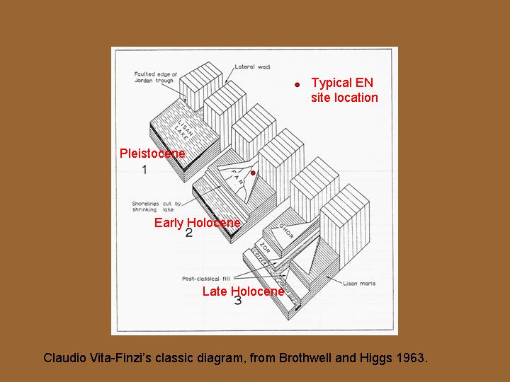
11) Block diagram illustrating three phases in the evolution of the Jordan Rift, from Late-Pleistocene (left), when much of the valley-floor was occupied by the Lisan Lake (predecessor of the Dead Sea); early Holocene (centre) when fans developed where watercourses entered the valley; later Holocene, with down-cutting of the Jordan valley and wadis, forming the present divisions of the landscape. Comments in red. From Claudio Vita-Finzi "Geological opportunism", pp. 31-4 in P. Ucko and G. Dimbleby (eds) The Domestication and Exploitation of Plants and Animals, London: Duckworth (1969).
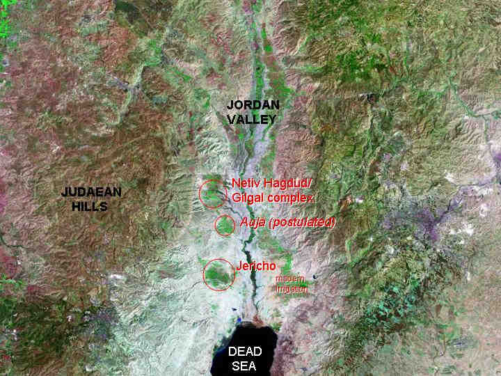
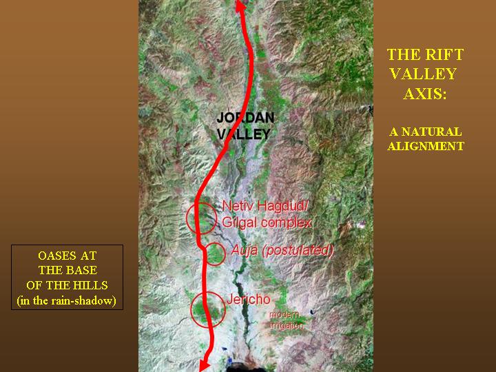
12) Jericho as one of a series of west-bank oases in the lower Jordan valley, fed by reservoirs in the Judean hills; note modern irrigation on the east bank. Both Jericho (Wadi Mafjar) and Netiv Hagdud and Gilgal (Wadi Salibiya) show PPN A occupation; a comparable site may be postulated for the intervening Wadi Auja. (Landsat 5)
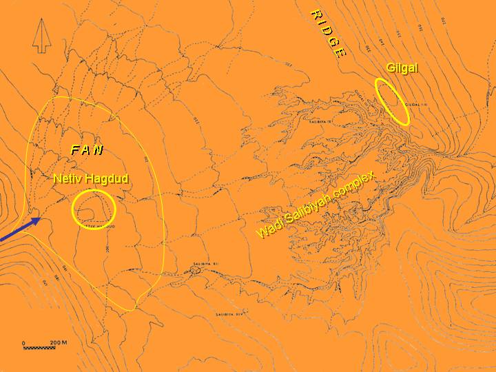
13) The Wadi Salibiya with the site of Netiv Hagdud at the head of the fan where the wadi emerges, and the site of Gilgal on a ridge at the base of the slope. These two sites demonstrate the alternative strategies of harvesting water: either at an emergence point (cf. Jericho) or at a constriction point (cf. Shillourokambos, Cyprus). Pre-Neolithic sites are located on the intervening surfaces. of the Wadi Salibiya complex From Bar-Yosef, O. and Gopher, A (eds) 1997 An early Neolithic village in the Jordan Valley, Part I: The Archaeology of Netiv Hagdud, American School of Prehistoric Research, Bulletin 44.
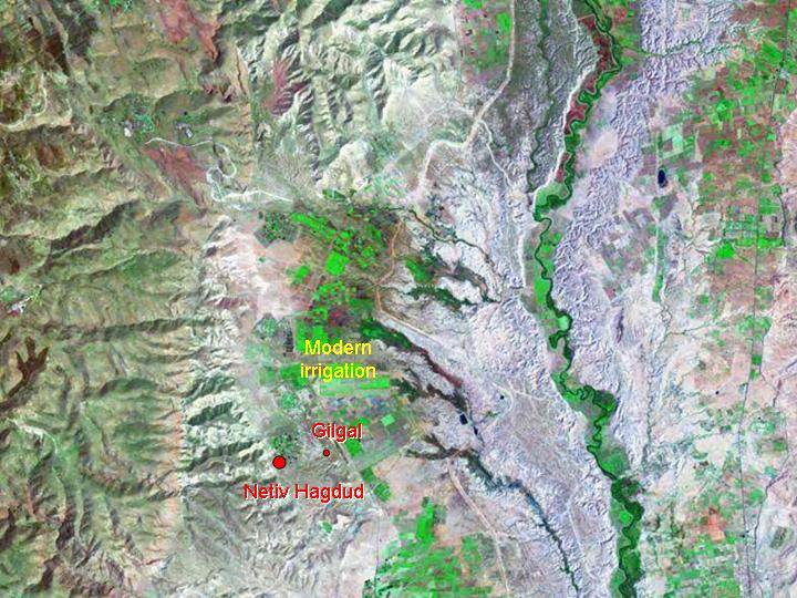
14) The wider setting of the previous map on the Landsat 5 image. Note the extent of modern irrigation, and the post-Neolithic incision of the Jordan valley.
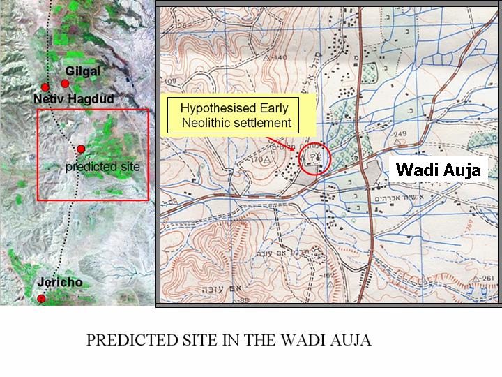
15) Predicted location of early Neolithic site in the Wadi Auja, in a position comparable to those of Jericho and Netiv Hagdud.
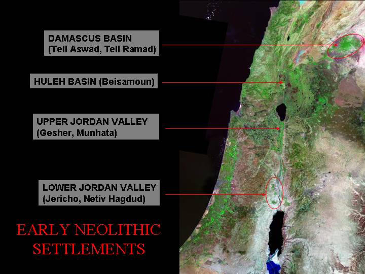
16) Locations of early Neolithic sites along the Levantine Corridor, in the Jordan valley and the Damascus basin, following the chain of otherwise dry lowland areas (in the rain-shadow of the mountains) but supplied by springs at the base of these mountain aquifers. (Landsat 5)
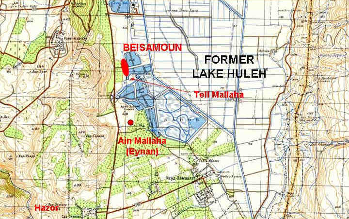
17) The locations of the major Late Natufian site of Ain Mallaha (Eynan) and the adjacent PPNB site of Beisamoun in the Huleh basin. The former lake has now been drained, but would have been open water like Yam Kineret, the Sea of Galilee. The sites occupy a low, apron-like fan which constricts the lake at its southern end. The fortified Late Bronze Age city of Hazor, on a hill overlooking the basin, testifies to the strategic nature of the route running through it, linking the Jordan valley with the Damascus basin and the Beqaa valley. (Soviet 1:200,000 Topographic series).
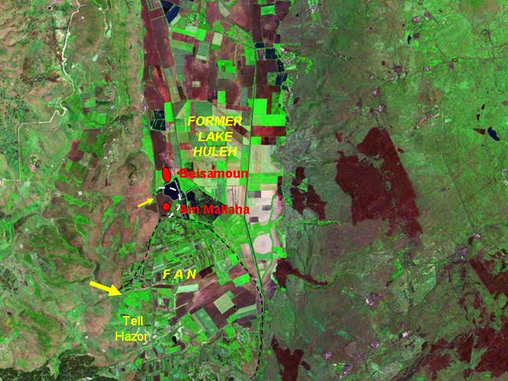
18) Landsat 5 image of the environs of the southern Huleh basin, showing the context of the previous map.

The Damascus basin is the first major stepping-stone between the Jordan Valley and the middle Euphrates, following the chain of oases on the desert side of the mountains which run parallel to the coast.
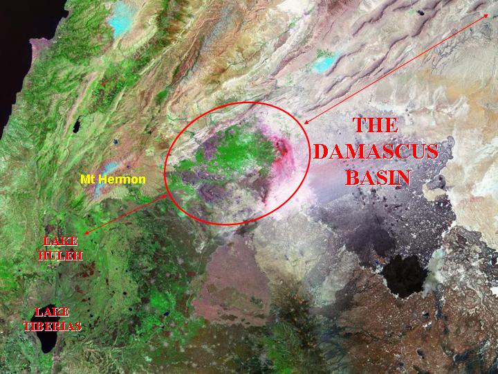
19) While the geological rift runs due north from the Huleh basin and the upper Jordan to form the Beqaa valley, between the Lebanon and the Antilebanon, the "Levantine Corridor" route follows the inner edge of the mountains, skirting snow-capped Mt Hermon to reach the lush, well-watered area (the Ghouta) created by the Barada river, which supports Damascus. (Landsat 5)
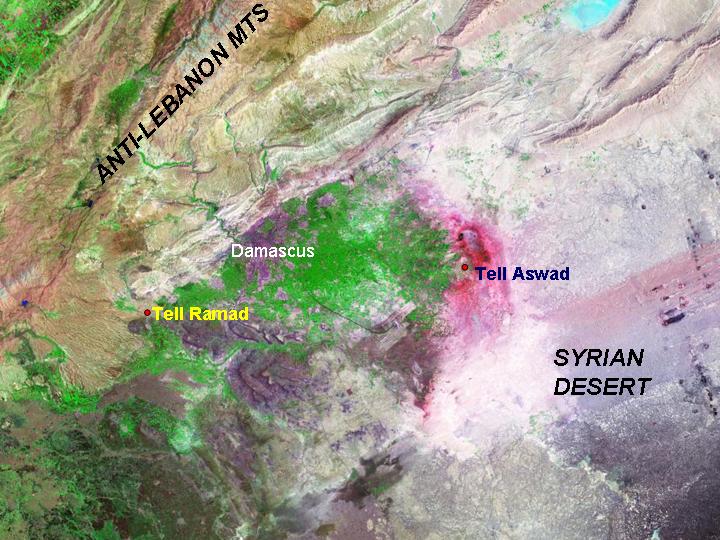
20) This Landsat 5 image shows the dramatic contrast between the mountains of the Antilebanon and the stark desert conditions further east, mediated by exotic waters flowing from the mountains, which create a large fan (green) with marginal lakes, now saline (red colour).
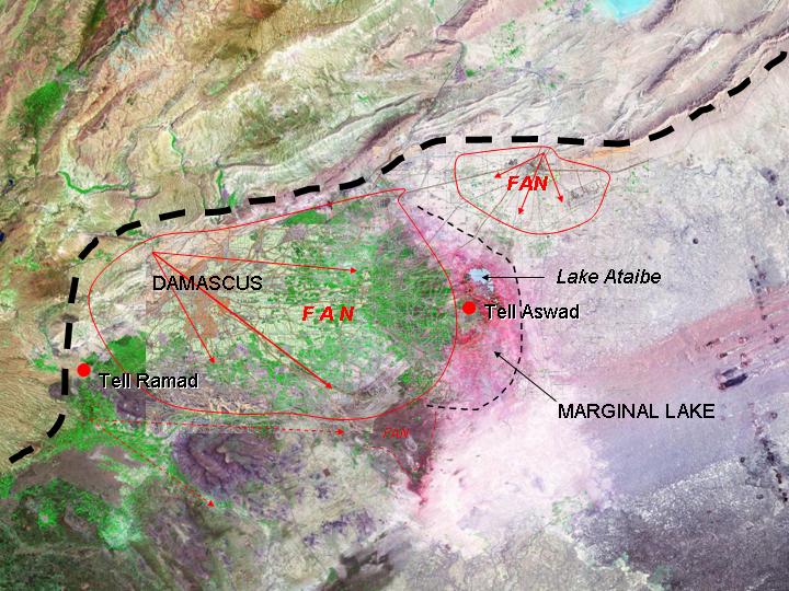
21) Interpretative overlay showing the main geomorphological structures of the Damascus basin. (Landsat 5)
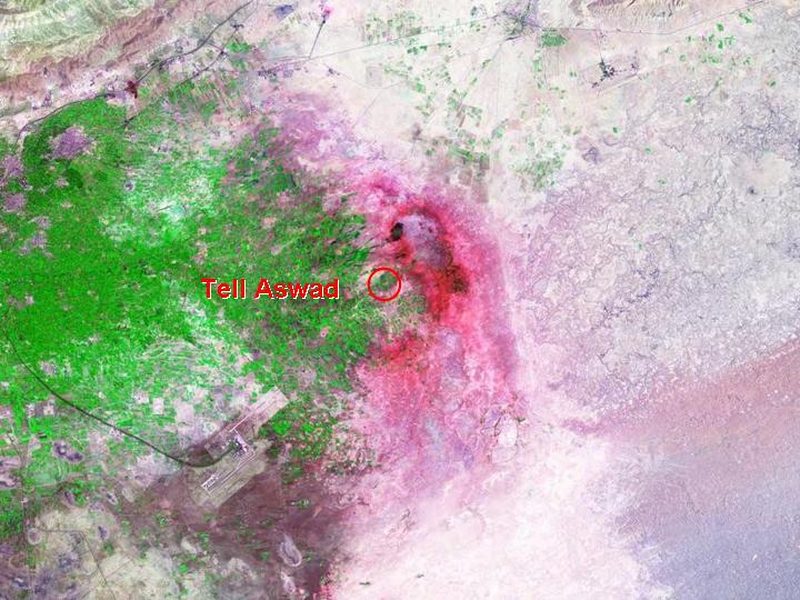
22) The approximate position of the early Neolithic site of Tell Aswad, overlooking a large lake around the margins of the fan, now represented by small remnant and rather salty lakes. (The modern feature is Damascus airport.) (Landsat 5) (See also Tell Aswad, and note that the last frame gives a more accurate site location that the one shown here)

The Euphrates bend in Syria is a strategic location, with links in many directions – north to Turkey, west to the Mediterranean, and eastwards to Iran, as well as down the Levantine corridor. At all periods of prehistory and early history, this nodal position was an important aspect of its inhabitance.
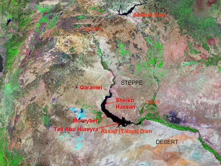
23) Key sites now lie lost beneath the waters of Lake Assad, the reservoir created by construction of the Tabqa dam. They testify to its importance in Epipalaeolithic (Natufian) times, at the transition to farming (PPNA/Mureybetian), and in the subsequent PPNB phases. (The area was again to become of axial importance in the fourth millennium BC, in the Middle and Late Uruk periods, when colonies of southern Mesopotamian origin were founded there). (Landsat 5)
24) One reason for the importance of this area lies in its linkage with sites in the Upper Balikh basin, on the way to the upper Euphrates, and routes across the Taurus into inner Anatolia, avoiding the narrow and gorge-like course of the intervening section of the Euphrates. (Note changes in present-day land-use at the boundary between Turkey and Syria, visible in the extent of irrigation.) (Landsat 5)
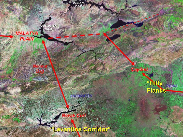
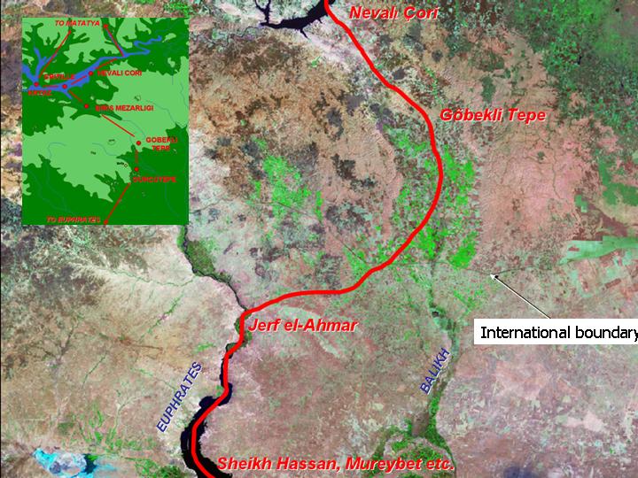
25) Passages across the Taurus mountains linked the world of the Fertile Crescent to the resource-rich highland hinterland of mountains and intermontane valleys. These routes (later followed by Assyrian highways and Roman roads) gave a peculiar advantage to strategically-places sites such as Çayönü, which account for their importance, longevity, and rapid changes of architectural fashion. (Landsat 5)
26) Early Neolithic (and, indeed, Epipalaeolithic) sites in the Levant were supplied by obsidian from Cappadocia, in south-east central Turkey. These materials must have reached entrepôts on the Euphrates bend by way of routes linking intermontane basins within the Taurus and Antitaurus. One such possible route (based in part on the pattern of Roman roads) is shown on this physiographic basemap; though it should not be imagined as a continuous highway, rather an axis of exchanges between local populations along the route. (1 km Globe DEM).
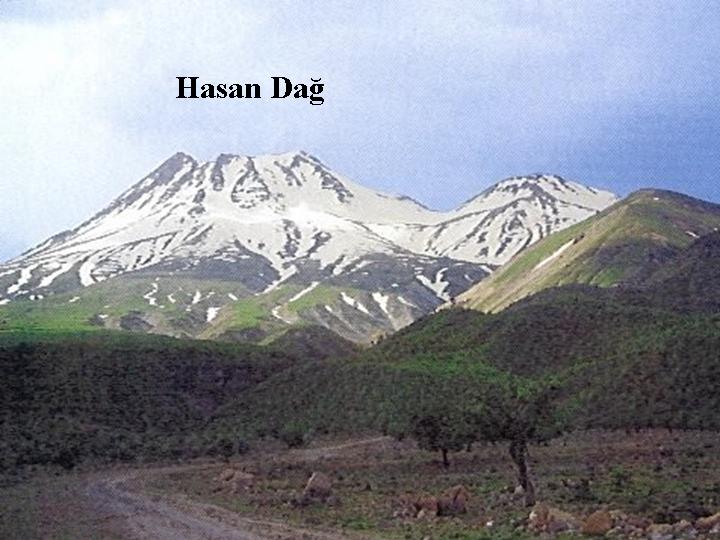
27) The volcanic mountains of Cappadocia supplied obsidian to a large area of the Fertile Crescent, and Cyprus, in the PPNB period. (Tourist photo.) See also The Obsidian Trade
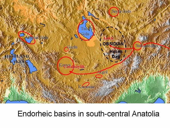
28) This physiographic map brings out the major internal-drainage basins in inner central Anatolia, many of which were foci of pre-pottery Neolithic settlement. The complex of Cappadocian obsidian sources is also shown. It may be that early footholds of intrusive populations were established around Sultansazliğigöl in order to exploit these deposits; but it is likely that there was an indigenous (Mesolithic) component to the communities established at Aşıklı Höyük and Çatalhöyük;. (1 km Globe DEM).
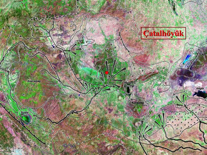
29) The position of Çatalhöyük on the major axis of surface-water input within the otherwise arid Konya plain, floored with lake-marls from an enlarged Pleistocene lake. Note the central position of the site in relation to the major fan of the Çarşamba çay. Geolomorphological map by Catherine Kuzucuoğlu (http://www.canew.org/archives.html), superimposed on Landsat 5 image. See also Sites from Satellites: Çatalhöyük
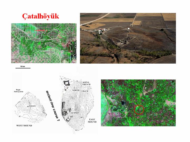
30) A miscellany of images: see http://catal.arch.cam.ac.uk/visit/visitEN.html for information about current excavations at the site
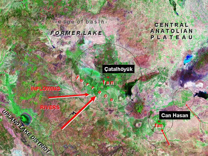
31) Çatalhöyük and Can Hasan: large and small examples of the same locational logic. (Landsat 5)
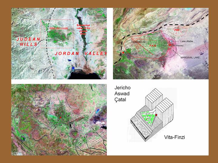
32) Jericho, Tell Aswad and Çatalhöyük, compared with Vita-Finzi's (1969) model, showing selection of terrains suitable for varieties of floodwater farming.

This section considers the arrangement of early Neolithic sites in relation to routes and axes of movement over the contemporary landscape.
33) As well as providing locations suitable for early forms of farming, the Jordan valley is a natural route of north/south movement. Small quantities of archaeologically recognisable materials (such as obsidian or marine shells) are known to have moved along it. While there is a danger of anachronism in using a modern term, it can be described as a "trade route". (Landsat 5)
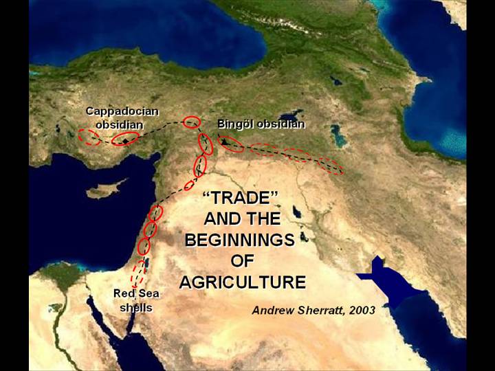
34) All the "settlement cells" occupied by early farming groups in the Fertile Crescent were linked in chain-like fashion, forming long-distance routes of exchange, circulating (for instance) obsidian in exchange for sea-shells (and certainly many other materials, including organic ones). Obsidian (which came from sources at various points in the volcanic belt to the north of the Taurus mountains, such as those in Cappadocia and near Bingöl), offers one of the most sensitive indicators of such traffic. The Levantine Corridor and the Hilly Flanks zone were axes of contact and exchange during the period when farming emerged, and the development of cultivation and domestication have to be seen within this larger framework. (Blue Marble)
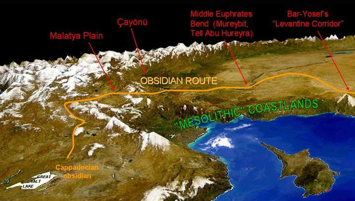
35) The Cappadocian obsidian route to the Levant, and the "Mesolithic" coastlands, circa 8000 BC. A (somewhat exaggerated) 3D view of the northern Levant and adjacent parts of Turkey, looking east, with Cyprus in the right foreground, dramatises these connections in the PPN, from the Euphrates bend to Cappadocia. Farming settlement initially avoiding the forested coastal areas around the Gulf of Iskenderun, here marked "Mesolithic". (NASA/GSFC: OrbView-2SeaWiFS on 1 km DEM)
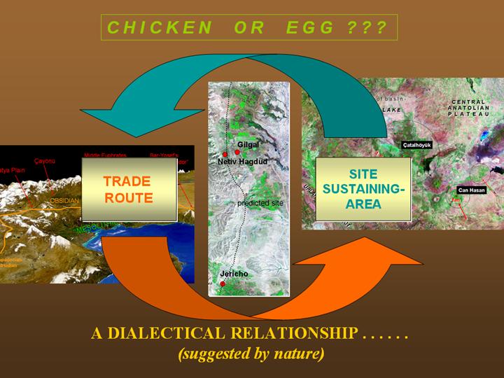
36) Which came first: the settlements or the trade-route? This is a question raised by Kent Flannery (as a dispute between the Real Mesoamerican Archaeologist and the Sceptical Graduate Student (The Early Mesoamerican Village, 1976, 283-6), and which divided "traditional" archaeologists (who believed in contact and trade) from "New" archaeologists (who believed in the primacy of local economy and settlement). The reality is likely to be a combination of both (in appropriate circumstances), in a mutually reinforcing manner, leading to larger settlements and greater trade flows – until conditions change, trade flows along different routes, settlement sizes decline, etc. This diagram attempts to capture the feedback loops within this process, and the way such structures may be initiated by structures in the natural world, in this case, the Jordan rift and the linear pattern of oases.
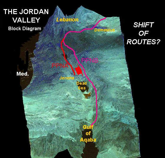
37) One such "switch" in trade routes seems to have occurred between PPNA and PPNB in the Jordan valley, with a shift of routes from one side of the valley to the other, to follow the long-distance route down to the Gulf of Aqaba which was known in Biblical times as the "King's Highway".
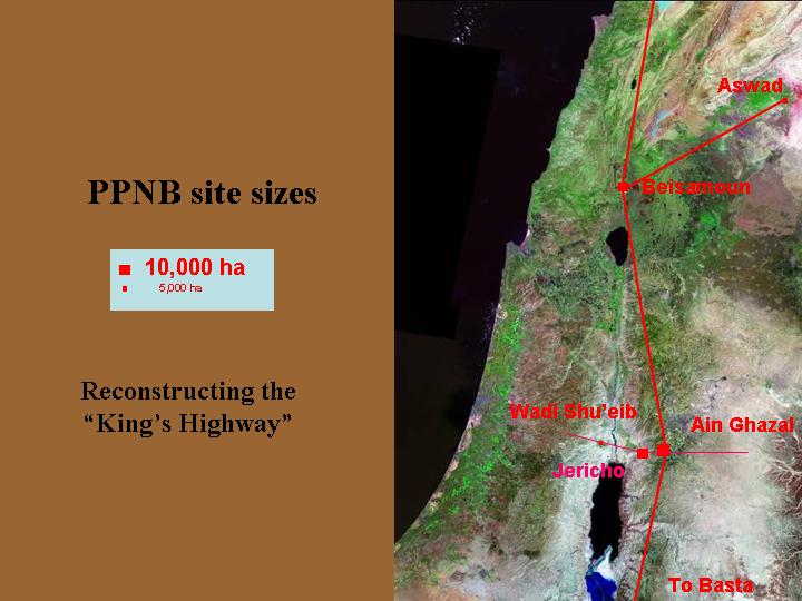
38) The notably large PPNB sites would have served as nodes in long-distance routes transmitting rare items along an axis stretching from the sub-tropical conditions (and Indian Ocean marine fauna) of the Gulf of Aqaba, up to the northern forests and steppes of Anatolia and their highland resources. (Other large nodal sites of this period are Tell Abu Hureyra and Çatalhöyük.) This monopolistic network would have been undermined when a multiplicity of other routes came into existence, notably those following the Levantine coast when farming began there in the later Neolithic. (Landsat 5)
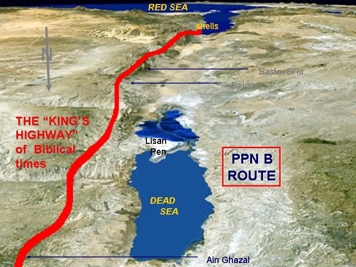
39) Looking south along the Jordan valley towards the Gulf of Aqaba, showing the course of the "King's Highway" and major PPNB sites on the eastern edge of the valley.

If routes and local resources were both important in generating settlements and trade networks, and led to mutually reinforcing patterns of growth, what implications does this have for the beginning of farming?
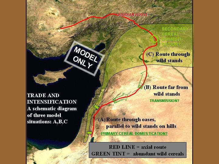
40) As a crude initial model, note the differing relationships between local settlement concentrations and the accessibility of wild cereals along different sections of the Levantine Corridor route. (A) In the south, the main stands of wild cereals are in the mountains, parallel to the route but at some distance from it; (B) in the central section, cereals may not have occurred in any abundance along the route; (C) in the northern parts, wild cereals are relatively abundant in areas directly adjacent to the route. In these circumstances, the artificial cultivation of cereals was more essential in the south, to sustain settlements of growing importance in the chain of oasis locations. From such a model, it might be hypothesised that cultivation leading to domestication would be earlier in the south, and introduced to the north (where secondary domestication of local cereals may also have occurred).
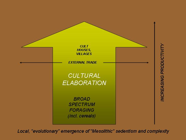
41) Using the model outlined above, the process of early Holocene development in the northern Levant and south-east Anatolia can be described as cultural elaboration on the basis of broad-spectrum foraging (with optional cultivation) in an area of abundant resources, leading to the emergence of sedentary settlements and cult centres at nodal points within the forest-steppe belt.
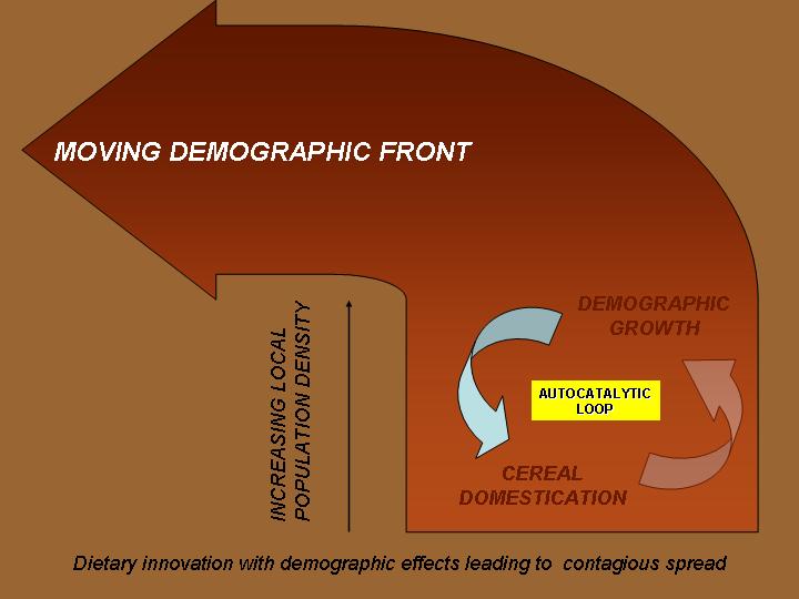
42) The situation in the southern Levant, along the Jordan valley (and perhaps on the Euphrates bend), can be described as cultivation-dependent sedentism in oasis-like locations, where varieties of floodwater farming could be practised. It is hypothesised that this obligate dependence on cultivated carbohydrates gave rise to a feedback loop linking population growth and an increasing scale of cultivation, generating a moving demographic front which began the process of spatial expansion.
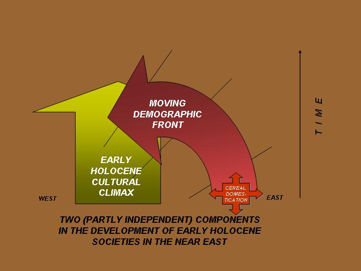
43) From 8500 BC onward, in the PPNB phase, these two elements increasingly fused, resulting in the classic "Neolithic package", carried to new areas such as Cyprus and the Anatolian plateau.
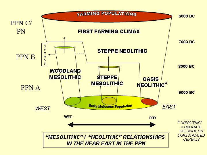
44) Setting these two elements in a wider context, to include "Mesolithic" populations continuing in wooded mountain and coastal areas (and only adopting farming in the later Neolithic, after 7000 BC), a more comprehensive model can be suggested, which incorporates these diverse pathways to farming.
These maps and images should be considered together with the arguments set out in the published paper "Diverse origins: regional contributions to the genesis of farming" (in S. Colledge, J. Conolly and S.J. Shennnan, editors, Origins and Spread of Agriculture in SW Asia and Europe: Archaeobotanical Investigations of Neolithic Plant Economies, 2005, UCL Press), with bibliography.
CREDITS: NASA Blue Marble true-colour global imagery (1km resolution). Landsat TM 5 imagery mosaic provided by NASA: "You may use NASA imagery, video and audio material for educational or informational purposes, including photo collections, textbooks, public exhibits and Internet Web pages.". (SPOT panchromatic image, orthorectified, 10m resolution, 1992-4)